5 Lands Coast Walkway Masterplan
The 5 Lands Coastal Walkway Masterplan of March 2012 was prepared in order to provide a permanent walking trail to connect the five coastal communities of MacMasters Beach, Copacabana, Avoca, North Avoca and Terrigal.
Works towards establishing the permanent walking trail between the communities or lands include:
* Upgrade of Captain Cook Lookout in 2012
• Installation of signage along the route of the 5 Lands Walk event in 2012
• Construction of an access pathway near 55 Del Monte Place to the old farmhouse site at the base of Winney Bay in 2015
• Construction of stairs and landings on the steepest part proposed permanent route in 2018.
The annual 5 Lands Walk typically attracts over 20,000 participants. While the current route of the 5 Lands Walk is busiest on the day of the event, it can be used throughout the year to enjoy our local coastal environment.
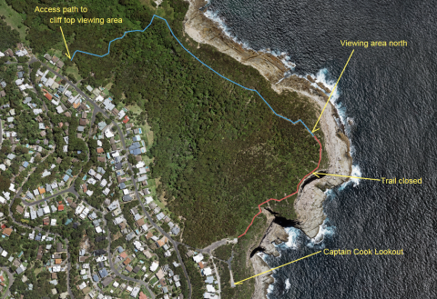
The ‘missing link’ of the 5 Lands Walk remains between the carpark at the Captain Cook Lookout and the top of the stairs constructed in 2018. Access to the clifftop in this area is not permitted due to the risk associated with the sheer drop of over 100 metres.
Council has considered a design to establish a route between the Captain Cook Carpark and the top of the constructed stairs, which is referred to ‘Stage two’ of the clifftop walk. There was also previous community consultation taken on several design options for this track. You can find out more about these design options at yourvoiceourcoast.com
No decisions have been made by Council about ‘Stage Two’ of the project in the absence of elected representatives. It is anticipated that consideration will be given to Stage two of the Winney Bay Clifftop Walk in the first term of Council following the local government elections of September 2024.
Public Notice – Closure of Winney Bay clifftop area
An informal section of the track along the cliff top at Winney Bay has been closed to due to community safety concerns.'
Council has undertaken geotechnical surveys as part of the design phase of Stage Two of the walk. As a result, a 130m section of the informal walk has been found to be within the unacceptable risk zone due to its proximity to the sheer cliff faces.
Barriers and signage have been erected on site to ensure walkers are aware of the restrictions. The formalised sections of the walk between MacMasters Beach and Terrigal remains open.
Community safety remains our priority, however we do apologise for the inconvenience.