Published On
06/05/2024Central Coast Council have been pro-actively and actively managing The Entrance Channel to minimise flood risk in alignment with the Tuggerah Lakes Interim Entrance Management Procedure (2022) which prescribes the flood-minimisations actions we should undertake based on water level predictions in consideration of entrance channel conditions.
As the channel had been in a heavily constricted state we have been pro-actively helping to get it into a more ‘flood-ready’ state by doing some pre-flood berm preparation works. These included scraping back sand to widen the throat of the primary channel and constructing a secondary pilot channel with the end plugs kept in place. Council undertook these pro-active works in February and again in late April.
Council has had eight items of heavy plant deployed to The Entrance Channel this week including 2x 30t Moxy dump trucks, 1x 12t dump truck, 1x25t excavator, 2x12t excavators and 2xD6 dozers.
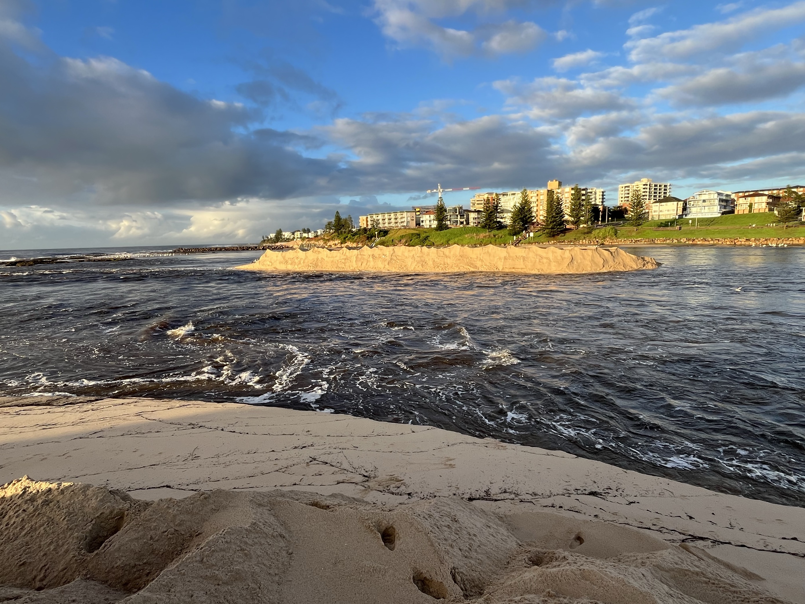
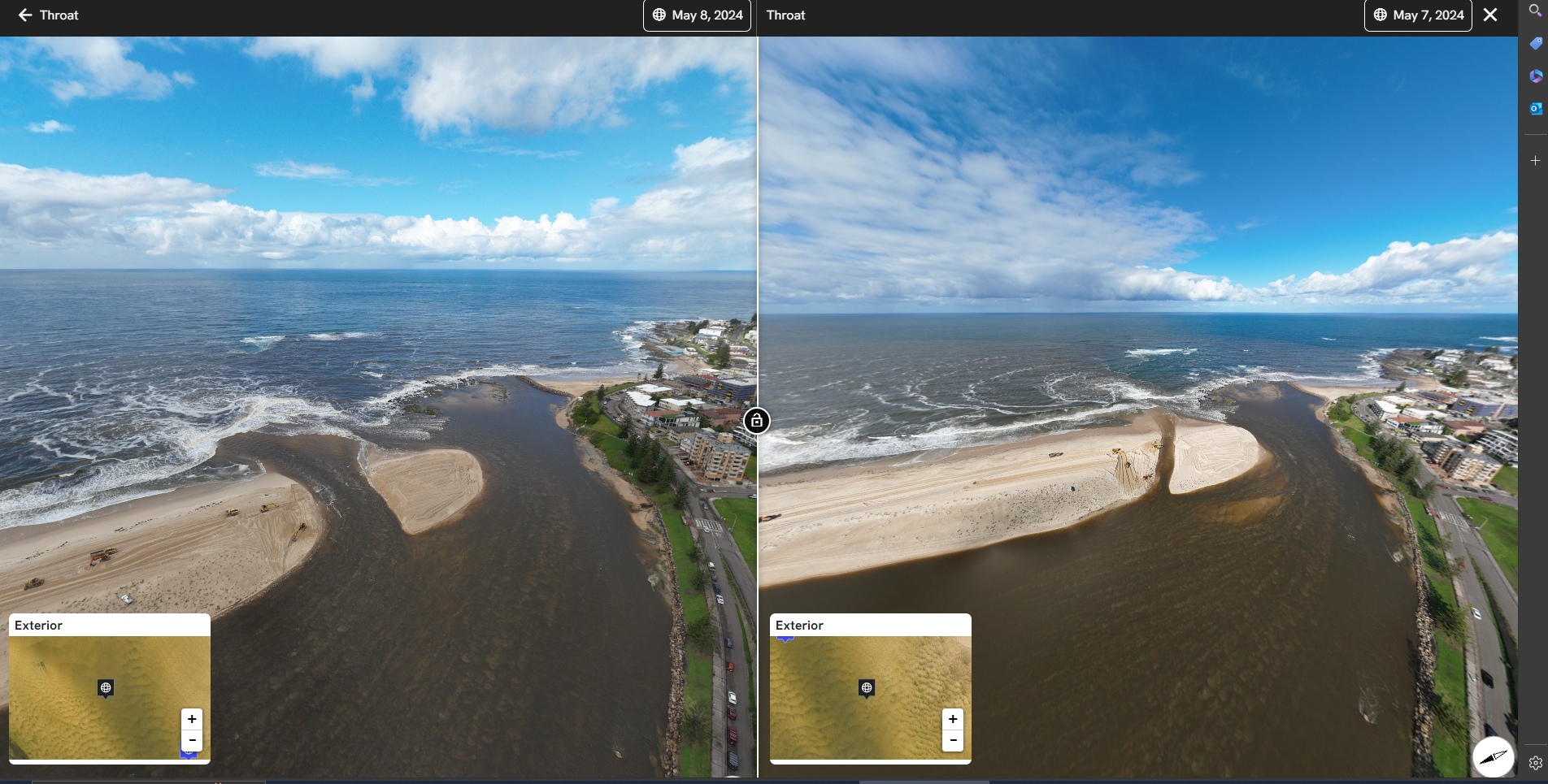
The secondary pilot channel was mechanically opened by removing the plugs on Monday once lake water levels reached an adequate height for water pressure on the opening to be great enough to ensure the new channel is successful. Minor infilling of the channel occurred during the overnight high tide but was dug out on Tuesday morning and has remained open and flowing to the ocean from that time, successfully increasing in width and depth due to scouring. Despite large flows of water coming into the lakes from the catchment, lake water levels are now steadily dropping.
It is important to note that we can’t dig the secondary channel too far north as that would risk causing severe erosion issues on the northern shore in the event of a major flood.
Recent challenges with facilitating greater out flow of flood waters from the estuary were not considered to be limited by the timing, location or amount of mechanical works being done on-site, but by two other primary driving factors:
- The relatively low flood level – although we appreciate the flood has had a significant impact on our community, the actual lake level still peaked fairly low at around 1.2m AHD. Indeed, Council manages openings at several coastal lagoons throughout the LGA, with the lowest being Terrigal Lagoon, which we do not open until it reaches a water level of 1.23m AHD. In opening at this level there are challenges in timing as the hydraulic energy based on the difference between lagoon and ocean height remains low. Higher floods of recent years resulted in greater hydraulic energy and shorter duration events.
- Recent tendencies of the primary channel to track south – since the construction of the NSW State Government groyne at the northern end of The Entrance beach, the throat of the channel has realigned south of the rock shelf. Historically the channel, even when constricted, flowed north of the rock shelf. This allowed for hydraulic energy during flood to help naturally scour the sandspit, not being limited by the depth of the rockshelf.
Why didn’t we open the secondary pilot channel earlier?
There are many benefits to keeping the end plugs on the secondary channel until triggers are met. For effective sand scouring to take place upon opening, there needs to be enough water depth in the lake to create adequate pressure to maintain the secondary channel in an open state. Concurrently, ocean tide and wave conditions need to be carefully considered as large swell or high tide conditions may result in infilling of both water and sand into the system.
Why don’t we artificially maintain a wide-open channel all the time (breakwalls etc)?
The sandspit which naturally forms across The Entrance Channel is actually a great masterpiece of nature, strong enough to hold water inside the perched estuary during periods of low rainfall yet soft enough to blow out during a flood event. Council management of the channel aims to find a balance between allowing the sand spit to naturally do its job during periods of low rainfall, and giving it a bit of a helping hand when heavy rains are forecast.
Tuggerah Lakes is a naturally shallow estuary, with an average depth of approximately 1.7m (Lake Macquarie averages 8m depth for comparison!) and the estuary is perched approximatly 0.3m above sea level so allowing sand to naturally build up across the channel during periods of low rainfall prevents the net loss of water from the estuary that would occur if the channel was wide open during these times.
Allowing the lake levels to fluctuate and occasionally rise higher than normal also immerses the lake’s fringing wetland habitats and improves mixing of the water between shallow nearshore areas and deeper parts of the lakes. It also helps to lift wrack (floating seagrass that has detached from the lakebed) that can get trapped along the shoreline and facilitate for it to wash ashore onto higher ground where it can aerobically dry and break down in the sun, reducing odour.
Why is the lake level taking so long to recede?
- Heavily constricted channel state: Ocean tides have been gradually pushing more and more sand across the entrance channel due to prolonged periods of low catchment rainfall. This is actually a very important natural phenomenon for shallow, perched estuaries; preventing the net loss of water that would occur from the lake system if the channel was wide open.
- Unusual southerly location of primary channel: The primary channel has also been following an unusual path in recent years, much further south than normal. This is likely the result of the groyne at The Entrance Beach, which was built by the NSW State Government in 2017 to maintain sand on the South Entrance beach. Unfortunately, an unintended consequence of the construction has been erosion on the northern side of the rock groyne which has encouraged water to flow to the extreme south of the channel, where there is a rock shelf limiting the depth and reducing its capacity to operate effectively. Council has recently made representation to the NSW Government asking for further consideration to be given to the impact of the groyne on the effective operation of The Entrance Channel.
- Lake level not high enough to maintain a secondary channel: Recent efforts to establish a secondary pilot channel were done pre-emptively and pro-actively, whilst lake levels were only at 0.8m, despite our Interim Entrance Management Procedure advising a lake level of 1.3m is needed to create enough water pressure to successfully maintain the pilot channel in an open state and allow the entrance to widen. During April, despite our efforts to re-dig the secondary channel open on multiple occasions, it continued to close over at each high tide because the lake level was not high enough to overcome the ocean energy pushing sand in.
Timeline of events
February 2024
Based on the heavily constricted classification of the channel, Council pro-actively chose to undertake optional non-flood entrance berm maintenance works. These included secondary pilot channel preparation works involving construction of a 40m wide pilot (secondary) channel through the berm, with the end plug to the ocean kept in place. This meant that the process of fully opening this second channel would be very efficient (once flood prediction and lake level triggers were met).
Thursday 4th - Saturday 6th April 2024
The BOM issued a severe weather warning for high rainfall for large parts of NSW, including the Central Coast and in accordance with the Entrance Management Procedure Council placed machinery resources required for entrance works at Karagi Point.
There was then a forecast prediction for a 25% chance of water levels reaching the 1.3m AHD trigger point within the next 4 days. As a result, the pre-flood Entrance Management Procedure was enacted which included pre-flood berm preparation to widen the throat of the primary channel north of the rock shelf to increase flow of water out of the lake.
Our procedure typically requires a 1.3m lake height to establish optimal water pressure to maintain flow through a secondary pilot channel. However, considering conditions, we chose to open the secondary pilot channel by removing the plug at low tide 12:30pm on Saturday.
At this time lake levels were about 0.8m. The primary channel and secondary channel were now both open.
Sunday 7th – Wednesday 10th April 2024
The high tide and wave action each night pushed significant volumes of sand into the secondary channel, and the lake waters weren’t high enough to have sufficient pressure to push this sand back out.
Works were conducted by Council crews at low tide on Sunday, Tuesday and Wednesday with machinery successfully increasing the depth of the secondary pilot channel and re-opening it on each occasion.
At this time, the lake height was between 0.88m-0.92m and the primary channel was open. The secondary channel was closing over each night and then been re-opened.
Thursday 11th – Sunday 28th April 2024
Lake levels remained below the minor flood threshold of 0.9m with no forecast predictions for this threshold to be exceeded and no justification for Council to conduct further works.
Lake levels remained at the higher end of the normal range, causing nuisance inundation to low lying areas and taking longer than normal to recede due to factors such as the alignment of the primary channel over the rock platform (due to impacts of the rock groyne) and lake levels not being high enough to create enough pressure to maintain the secondary channel in an open state.
Monday 29th April – Friday 3rd May 2024
Rainfall forecasts predicted a wet weather event for the following weekend so pre-emptive works were again commenced, exceeding the requirements of our Interim Entrance Management Procedure.
Excavators and bobcats successfully removed sand from the end of the sand spit, increasing the width of the primary channel and encouraging flows to the north of the rock platform.
Council crews also constructed a new version of a secondary pilot channel, modified based on the outcomes of the works conducted in early April. This pilot channel is aligned at a 45-degree angle across the sandspit and has plugs on both the lake end and the ocean end to prevent wave overtopping and shoaling.
Finally, crews also dug a new ebb channel parallel to the sand spit, removing sand that had been pushed into the lake by ocean forces earlier in April.
Monday 6th – Thursday 9th May 2024
The secondary pilot channel was opened by removing the plugs on Monday once lake water levels reached an adequate pressure for the opening to be successful. Minor infilling of the channel occurred during the overnight high tide but was dug out on Tuesday morning and has remained open and flowing to the ocean from that time to now.
Strong outflows have successfully created significant increases to the depth and width of the secondary channel on an ongoing basis and the lake water levels are steadily dropping, even with large volumes of water continuing to flow into the lake from the catchment.
Dump trucks joined the excavators and dozers on the beach this week to relocate the sand that had been cleared from the primary and secondary channels. This sand is being taken off the sand spit to reduce the risk of it being displaced back into the channel, and is being used to provide additional reinforcement against erosion to North Entrance beach, including near Hutton Rd and the carpark.